Various trends influence the Geospatial Information Systems market: the adoption of digital technologies, out-of-the-box GIS offerings, cloud and mobile deployments, and location-based analytics. All this knowledge I gleaned from ARC Advisory Group’s recent research on Geospatial Information Systems. But what caught my attention was its use in transportation and why it is so important. When we travel, maps and navigation systems are high on our priority list. Many of us use them only when we are in a new place or lost, but geospatial information is transforming the transportation industry in many ways. Online maps have become one of the most evolving industries with the continuous development of digital maps and navigation systems. The world over, conversations revolve around urban traffic congestion and how much time it takes to get from Point A to B. So, when I learned that GIS can effectively be used for traffic analysis and management, my interest piqued.
How Does GIS Help?
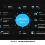
GIS is a powerful tool that enables the analysis and visualization of spatial data, allowing for the integration of geographical elements into transportation planning and management. The benefits of using GIS in transportation are improved efficiency, safety, and sustainability. GIS plays a significant role in traffic analysis by providing tools for managing and analyzing traffic data, which helps in understanding traffic patterns and making informed decisions for traffic management. In a nutshell, here’s how GIS contributes to traffic analysis:
Traffic Data Management: GIS platforms enable the collection and storage of traffic data from various sources, including sensors, cameras, and GPS devices. This data is geographically referenced and can be used to monitor real-time traffic conditions.
Traffic Pattern Analysis: GIS software allows for the analysis of traffic patterns over time. By visualizing traffic data on maps, it’s possible to identify trends, peak traffic times, and areas of congestion.
Route Optimization: GIS can be used to find the most efficient routes for transportation, considering factors such as distance, travel time, and current traffic conditions. This is particularly useful for fleet management and logistics.
Accident Analysis: Traffic accidents can be plotted on a map using GIS to identify accident-prone areas. This information can be used to improve road safety measures.
Traffic Forecasting: GIS tools can help predict future traffic flows based on historical data and trends. This can assist in planning infrastructure improvements and traffic management strategies.
Public Transportation Planning: GIS is used to plan and optimize public transportation routes and schedules, ensuring better coverage and service for the community.
Boon for Urban Planners
Analysis of all these patterns and factors can help urban planners develop a GIS-based transportation management system. GIS solutions can serve as an effective planning guide for traffic management, offering strategic insights into applications and forecasts for various projects. Ensuring interoperability between GIS and other systems is crucial for efficient traffic planning and management. The results of using GIS in this manner could include reduced congestion, shorter travel times, and improved
safety.
Companies like Hexagon offer solutions that enable faster decision-making by turning complex data about people, places, and assets into actionable information. GIS platforms from companies like SuperMap GIS and Esri have capabilities in geospatial data management and visualization, which are vital for transportation planning and management. Visualizing assets in transportation infrastructure management offers several benefits that enhance decision-making and operational efficiency. Key advantages include enhanced communication and efficiency, cost saving, and risk management.
Concluding Thoughts
The future of Geospatial Information Systems in transportation is upbeat, with emerging technologies and applications expanding its horizon. For example, the development of autonomous vehicles will require sophisticated GIS systems to navigate and operate safely. Field visits to scout for business opportunities are now unnecessary. With geospatial data all this can be done easily, while providing rich insights that help in the decision-making process. As the need to collect and analyze spatial data rises across industries, GIS will become even more pertinent to companies and governments. It will be interesting to see how the transportation industry optimizes the usage of GIS.
The post Geospatial Information Systems (GIS) for Efficient Transportation Management appeared first on Logistics Viewpoints.